Adding Oregon to our orb

Picking up on my old journals:

A month of rain: 2½ inches in December: snow, then melt. Our view of Rattlesnake Hills (rising behind our shack) washed out in fog. Ground soggy, making up for drought.

Vol. 50, 11:II:78

(first trip to Portland, a city that would become our alternative to Seattle, though we never got to know it as well)

longhorn steer on Satus Pass Highway
a longhorn?
Yakama Reservation

Quaker meetinghouse in an old storefront
Service Committee on one side
First-day school upstairs
or a Friends’ apartment? (caretakers

overwhelmed by the Native display at the art museum but not the rest of the collection

  • Tlingt Cannibal Society dancers, long-beaked masks opened by strings
  • (bird that eats human brains, serpents that swallow whalers)
  • mountain sheep horns turned into spoons
  • halibut fish hooks with intricately carved animal-peoples as bait
  • or a life-size cormorant, hook sewn on with sea lion gut

Portland-town, calm as Philadelphia

Asian and Native
with an Anglo overlay
afternoon, clouds cleared
revealing Hood, proud and pink over all

– Rainier and St. Helens in the soup
but where, oh where was Adams?

Still so ignorant regarding this land

  • Haven’t yet seen rattlesnakes beside the rocks
  • Survived avalanches
  • Fished for salmon, ridden a horse, felled Douglas fir or hemlock
  • Sailed out from the coastline
  • Crossed wrinkled glacier
  • Stood atop Rainier, Adams, Hood, or Baker
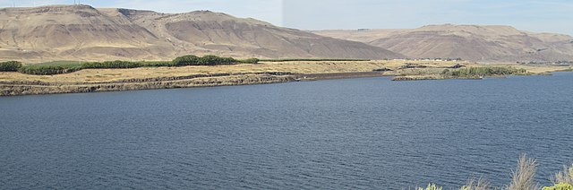
 

Much of the Columbia River runs through desert before getting to the lush greenery in the Cascades and on westward to the Pacific. Much of the route forms the border between Oregon and Washington state, Here’s a taste of the eastern Columbia River Gorge downstream from the Dalles, Oregon, looking into the “Evergreen State,” photo by Chris Light via Wikimdedia Commons.

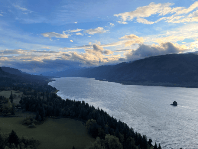
As for the more common impression, consider this photo by Lena Chang/USFWS, also via Wikimedia Commons.
 ~*~

14:V

Climbing Clemens in fog and rain, encountered my first rattlesnake, dead in the logging road; five rattles. They gain a new one every time the shed their skin, usually three times a year.

Old-timers saying this is greenest, mostly intensely flowered spring they can recall.

17 june

Slept till 9, met Whiz and drove from the Nile to Tieton ranger station, then out, in six-foot snow pack to the Timberwolf Lookout — the forest fire watch building is gone but great panorama of Adams, Goat Rocks, Rainier, the Stuarts — Mount Glacier clear, a ghost of Baker, and crown of St. Helens. Plus Aix, Bismarck, Nelson, Butte, Shellrock, Ironstone, and others.

Kitty, off to Seattle with Michael. Platonic, she insists.
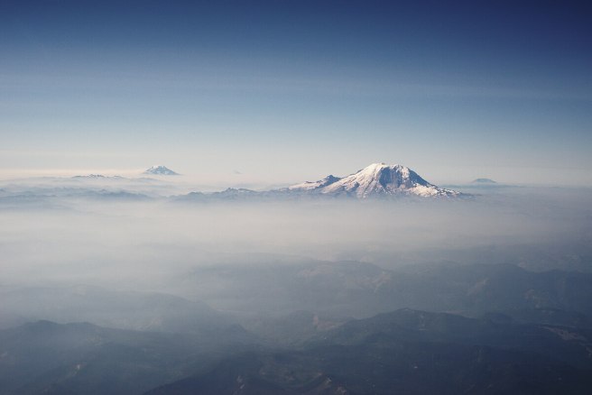
 

Stratocone volcanic mountains poking through clouds are Mount Rainer, center, Mount Adams, left, with a very tiny Mount Hood appearing halfway between if you zoom in; St. Helens rises to the right.. Photo by Dllu at Wikimedia Commons. A distinctive feature of the Cascade Range is stratocones about 50 miles apart from Lassen Peak in California to Mount Baker near the Canadian border.

~*~

 20 Aug, Sunday

Entries lately: weekend to weekend

Sweet smell of conifers in the passes — rain at White Pass

everything clouded in

U.S. 12 still showing washout debris
wrecked guard railing
and other signs of last winter’s thawing and rains

4 Sept, Labor Day

Ginko Petrified Forest (at Vantage, where Interstate 90 crosses the Columbia)

Once, 10 or 15 million years ago, 200 species of trees grew here … the Cascade Range, not yet up, left ocean rains to come far inland (mahogany, maple, magnolia, Douglas fir, spruce, elm, ginko, box elder, beech, butternut among the common examples)

When the lava flows rolled over all, only the waterlogged trees didn’t burn … thus forming this site, one of seven major ones in US, and the one with the most species.

Wanapum tribe, peaceful, never declared war on USA and thus no treaty: and thus, alas, no reservation, no land = seems to sum up too much of Amerikan political and economic system, including judicial-legal mysterium frateritas …

~*~

Sometimes — no, too often — I feel or am wrongfully identified in a situation, perhaps because I do not submerge myself solely in a field — so that within a convention of journalists I may seem to be too ethereal, artsy, not politically-addicted enough, a health-food addict, whatever — yet among poets not hip enough, too square, too wealthy (!) or whatever: even too success oriented.

[Success? Guess that rules out poetry.]

A drive today, up into the Horse Heaven Hills … no irrigation system in sight, a few trees by the gully …

~*~

From Spiralbound Cascadia with commentary.
 

Beyond the canyon, mostly

When it came to the great outdoors for us, the year 1977 early on presented us with a trip that settled in E’burg rather than a few more hours on to Seattle. We found refuge in the Outrageous Taco, a freak center in an old beer hall turned pizza/taco/deli quiet with live music and free poetry journals to circulate … a sense of pleasant decay (a $2 movie nearby) … incense in the air, too. We would return frequently … a good selection of new and used books, too.

Homeward by the Canyon Road, walked over the swinging bridge at Umtanum Creek, Kitty screaming, scared, delighted, a future point for a hike …

~*~

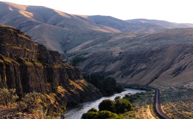
The Yakima River Canyon stretches 27 miles through three major ridges between Yakima and Ellensburg, with summits that rise more than 2,000 feet in places. A railroad and two-lane highway cling to the base beside the river.

In late February, we made our Umtanum ascent, including the bald eagle observation, the first in the valley in 25 years. It was the middle ridge, as I recall, and forms a pivotal chapter in my novel Nearly Canaan.

Thinking of my nature poems … man, the legions of demigods, takes something away, reduces the richness of the land … Nancy Trueblood’s “in the mountains I feel closer to God” … limits the diversity of the species, the expansive quiet, the wonderful circling weaves … in Indiana, my nature poems were often at the edge of the woods — the interface of man, land, and seasons … historical depth where farms sometimes expressed a harmony … a deep cold springhouse, a summer porch … the mountains here, ever green or, like our desert ridge, light brown, are something else … and man adds nothing …

~*~

10 July, Sunday

Drove along Sauk Creek to Stevens Pass … [north of Ellensburg]

Gold-mining remains … introduction to Leavenworth and then the North Cascades …

Leavenworth, with its Swiss Alps festive mood … shame that something similar cannot be created/sustained in “American” or Native authentic theme … maybe something to do with America’s lack of holy rivers and mountains or maybe our flat “Christian” approach to life … (Swiss Calvin not withstanding)

~*~

18 July … apricots gone

~*~

31 July/First-day evening

No entries in a week —

Last Sunday, left early for Seattle (after a midnight Saturday shift) to meet Bill and Mig Dietz and Curtis and Jacquie. The whole port city bit: winos, sailors, loggers, porno shops (me, buying newspapers!), Blacks and students, crowded Sunday parks, jazz. Got to know Curtis better, though their planned North Cascades backpacking got jettisoned by Jacquie’s emergency retinal surgery. His gentleness and humor, plus his Seattle friend Bob Green. Our disappointment with the Seattle art museum, then learning it was cut in half, with anything modern at City Center. The aging freaks and the strangest cats.

Met the Dietzes for dinner at Ivar’s, pier 54. How beautiful these people are. Bill’s ability to melt Kitty’s sharp questioning from Jacquie …

Had salmon, scallops. [Not crab?] The Yakima, a sleek new ferry, in the next pier. Seagulls and seafoam.

Heard of one Friend’s decision to go to Australia, though she didn’t have enough cash to get a visa. Hitched to SF, her first ride was with a trucker who CB’d ahead, starting a chain that got her safely, quickly down the pike — always the next ride waiting. Got to the SF consulate office, sat outside till she got a “hardship” visa. Got her case heard. And went on her way, after staying at Friends House.

The uncommonly filling spirit at our parting. So high, elated from this visit, happy to be together, laughing aloud on our long drive home with a new moon.

~*~

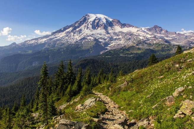
Mount Rainier, photo by William B. Jacobs via Pexels.

Fremont lookout

Rainier National Park

7,200 feet sea level

Kitty joined me in the ascent from Sunrise; thought she’d stop at Frozen Lake but seeing children’s tracks felt shamed into continuing. Amazing Alpine natural gardens …

Clearest day one could hope for: Adams, Goat Rocks sharp view from the trailhead, yet a violet haze layer over Puget Sound from Olympia to Mount Vernon.

Next page a sketched panorama map showing Mount Baker, Glacier peak, and the Stuarts … plus notation, “Olympics a blue ragged line riding above the haze.”

Sitting up here’s just like riding a cloud.

And thus we are cloud-riders being ambushed by ’monks,

the fearless chipmunks attempting to ride our lunch …

~*~

From Spiralbound Cascadia with commentary.
 

Not all of my exploration of our new world was on foot or on wheels

My encounters with the unfamiliar terrain of the Western mountains and desert had me reading everything I could find. The public library was a good start.

As I noted:

Rainier, honeycomb mountain, radiating heat under all that ice and snow — so fragile a good explosion could level it all … a new appreciation for “the temple tops” …

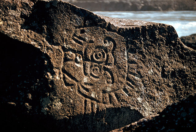
Regarding petroglyphs at the Dalles, to the south of us on the Columbia River:

“It seems impossible to decipher these inscriptions satisfactorily as it is not likely anyone except the makers and those living at the time the work was done could tell what was meant by them” — Newcombe, 1907

Also in Beth and Ray Hill’s Indian Petroglyphs of the Pacific Northwest, 1974, University of Washington Press:

“To make my name good” as a Northwest Native’s goal in life …

~*~

Petroglyph from the Columbia River at Rocky Reach Dam Museum, Chelan County Washington. Rock was rescued from the shores of the Columbia River before the dam flooded it, but many more were not saved. Photo by Thayne Tuason.


Indigenous petroglyphs in Columbia River Gorge near the Dalles Dam by U.S. Army Corps of Engineers, photographer unknown.

~*~

My explorations fill a number of poems and much of my novel Nearly Canaan and of Kokopelli in the Secret Side of Jaya. In fact, I’ve considered the place to be a central character in itself.

~*~

One book I found most useful in understanding the social differences in the Far West was Anti-California. Many of the points its author raised regarding the Golden State fit what I was seeing in the Pacific Northwest. For instance, few children grew up within a day’s drive of their grandparents or aunts and uncles. He saw that as extending into social life in general, which tended to be more polarized, using the Roman Catholic church as an example in having both one of the most conservative cardinals in the world as well as an entire order of nuns that broke away. (I could add that Quakers there came in two opposite camps, liberal “unprogrammed” meetings and pastor-led evangelical churches.) You get the idea. The author had been a correspondent for Newsweek magazine and other respectable periodicals. I didn’t recall the 1971 book’s subtitle, “Report from our first parafascist state,” or know anything about the author, Kenneth Lamott, father of novelist Anne Lamott. As I’m now hearing, he was quite a flamboyant character, to put it mildly. I do wonder how I’d see that book now.

~*~

From Spiralbound Cascadia with commentary.


My initial explorations in the Cascades

The primary attraction had been the mountains. We were in the foothills on the eastern flank of the Cascade Range. I was getting out into the wild probably every week from summer to the start of winter. Here are a few excerpts.

Darling Mountain

One of my first exploration, maybe the first, was on a Tuesday I had off work, when I drove up the Middle Fork from Tampico and then logging roads to Darling Mountain crest. Sheep scats and tracks around the snow and awesome meadows. Old site of forest fire lookout, since torn down. Climbed a dead tree to enhance the view. Mount Hood, above clouds. Adams, thrusting into them, closer. Goat Rocks across the way, and St. Helens’ perfect cone beyond. Straight ahead, following the road, Rainier thicker into the clouds somehow superior to the others. Then, a golden eagle sailing straight toward me, turning off perhaps 30 yards away, soaring off, circling briefly, and disappearing. With my guest status, I gave gratitude.

Deep forests were extraordinary.

I had no idea that this was on the second-highest logging road in the state.

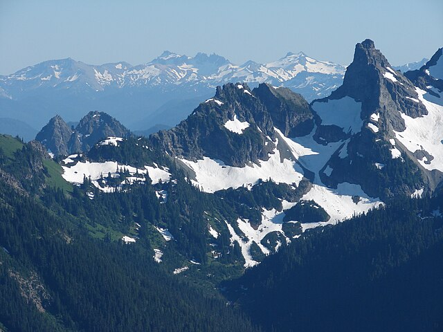
Cowlitz Chimneys (center) with the Goat Rocks (background) from Sunrise point on Mount Rainer, photo by Steve Redman at Wikimedia Commons. 

Rainier route

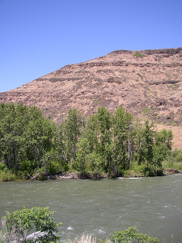
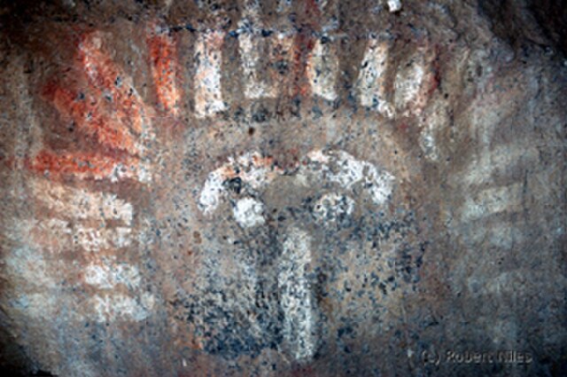
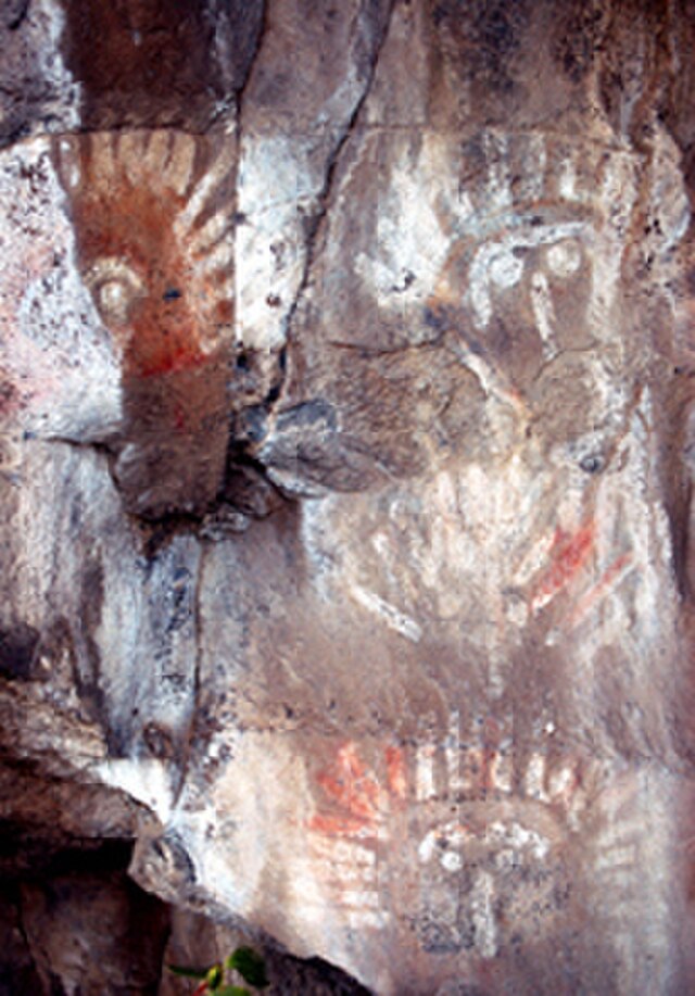
On another trip, on my way to Mount Rainier, saw my first petroglyphs (rock inscriptions) and petrographs (rock paintings) outside of Naches. The paintings looked a little faked — red and white, perhaps with a little blue or red.

They were found near where the Naches and Tieton rivers veered off westward toward the Cascade Range. Photo by William Borg.


Photographs by Robert Niles via Wikimedia Commons.

Our routes to Rainier were progressions through ecosystems that became familiar over repeated exposure as we drove from sagebrush desert into ponderosa pines and reservoirs of future irrigation waters on our way to the high country of the Cascade Crest and the rainforests beyond.

Rainier hikes inspired many poems as well as scenes in my novel Nearly Canaan.

Each day trip was intoxicating.

To the south

John Day Dam in Columbia River: fish ladder and 80-foot drop of locks: air in stomach, at man’s mass of cement: aluminum company by the RR tracks.

Steam locomotive at Maryhill State Park, reflecting Sam Hill’s source of wealth: Maryhill Museum of Fine Arts, his castle above the palisades, green lawn dropping off into clouds. The sculpture studies by Rodin the claim to fame. During the trip, pondering Mount Adams vs Rainier …

Sam Hill Memorial Bridge and Columbia River, seen from Maryhill Museum of Art, Maryhill, Washington. Oregon at top/right. Photo by Joe Mabel at Wikimedia Commons.

~*~

Along the way

Sweet vinegar smell of hay [up to 5 mowings a year in the interior Far West; the hay was grown in the sunny lands east of the Cascades, and much of it was trucked to dairy farms and other livestock operations on the rainy western side of the mountains].

~*~

From Spiralbound Cascadia with commentary.
 

Acid test environmentalist and poet: Wendell Berry (1934- )

My introduction to Berry came in reading his Long-Legged House while sitting on a gorgeous Navajo rug on the floor of the Ostroms’ contemporary home atop a wooded ravine in southern Indiana. It was a magical matrix, considering the story.

Berry was the embodiment of back-to-the-earth, having returned to his native Kentucky in 1964 and taking up farming by horse teams (or maybe mules). He did so to the consternation of colleagues in Manhattan who argued that he was just beginning to make a name for himself and that he’d lose his momentum and start writing sentimental verse about bluegrass.

Instead, he struck gold. His poems grew from real friendships and longstanding relationships. A bigger calling came in his environmental advocacy, especially as it expanded into real economics that countered the bean counters whose views neglected the value of parents, conservation, health, and the like. It even led him to a radical Christianity, including pacifism, and work with the Amish, where he met David Kline, whose weekly birdwatching columns were collected into a wonderful book, Great Possessions, which Berry helped shepherd to publication. (It’s about much more than birds, believe me. If you’re curious about Amish life, I’d suggest starting here.)

There’s something that’s much more life-affirming in Berry’s writing than in Robinson Jeffords’ strong but misanthropic nature poems from a generation earlier.

Berry had noted that his efforts at rebuilding the soil on his farm took 16 or 17 years to show signs of rebounding. It was something I later observed in our gardening in Dover, dealing with what my wife called Dead Dirt. Over the seasons, ours began to soften and then welcome earthworms and finally flowers and vegetables.

So it is with Berry’s pages.

Here I am living in a most photogenic terrain

Others have pointed out that most of the places I’ve resided in have been rich in natural beauty. While I’ve dampened that with an argument that you can find beauty wherever you are, or at least visual stimulation, I do have to concede how rarely that’s the case.

Many places, in fact, are brutal on the eyeballs.

Part of the attraction to Eastport for me was, after all, its access to wilderness and a rugged shoreline. Good shots seem to be waiting everywhere.

It shouldn’t be surprising that I’m overwhelmed by the number of solid photos I’ve been taking. How on earth is one supposed to organize them, much less share them?

It’s not like the old days of light meters, F-stops, film, or even focus, either.

Digital makes it a snap. All you have to do is look and see something.

And, yes, sometimes the camera – or cell phone – sees something more.

Eastport is a pedestrian-friendly village with old houses and storefronts, meaning more variety and detail than you’d find in the average drive-by suburb. It’s surrounded by forests, shorelines, and streams that present more opportunities. No wonder we see people pointing their lenses everywhere, and not just for selfies.

Where are all of these images going to go, anyway?

Red squirrel jitters

Squirrels were a pestilence back in Dover, raiding our garden and devouring the crown molding in our barn, in addition to some damage to the house itself.

While deer are a problem here, we haven’t had squirrels.

But the other day, I looked up from my keyboard and saw a small red squirrel scampering across our brush pile.

A few minutes later, my wife, working in another room, called out to say she’d seen a squirrel.

“A red one?”

Yep.

They’re worse than the grays we had, in the opinion of many.

So far, at least, it hasn’t been back.

Cross our fingers. We really no longer see them as cute.

Our old garden has been obliterated

People used to walk down our street in Dover just to admire our garden. They told us how much pleasure and peace it gave them. It also attracted a range of wildlife, including hummingbirds, butterflies, or the occasional turkey or fox.

Throughout the year, the garden also led to many photos you can still find here at the Red Barn.

It was, by many standards, funky. The weeds were never completely controlled, but it was prolific and made good use of what we sometimes called the Swamp, after its mucky clay soil in late spring and early summer. Our pet rabbits delighted in much of what we picked there, too.

The new owners, alas, have bulldozed all that. The strawberries, raspberries, blueberries, currants as well as the raised beds and shrubbery screens – gone. Twenty-years of reclaiming the once tired soil and then dining well as a result – gone. Naturally, we’re lamenting, knowing how much more they must be spending on groceries that won’t be as fresh or tasty.

We have to recognize, of course, that we’ve left all that behind and no longer have a say in the matter.

But we still feel sad or even a tad angry. Ahhh!

This is a great place to enter the twilight zones

Here in Way Downeast Maine, many dawns would blow you away, at least if you’re awake in time.

It’s not just when our closest star comes into view but also the vast unobstructed sky over the bay and the ways neighboring Campobello Island interact with the growing light.

As I’ve been finding – and you’re seeing in some of the photos here at the Red Barn – much of the glory occurs in what’s officially the twilight zones, defined by how low the sun is below the horizon.

These zones are otherwise known as dawn and dusk, apart from Rod Serling’s once upon a time spooky black-and-white TV episodes.

And these are longer and more pronounced the further away from the equator they are.

I’m on the 45th parallel, halfway to the North Pole and its days of endless summer light or winter darkness. Meaning our twilights are much longer than what happens in most of the rest of the continental U.S.

Checking our local weather forecasts, I’ve noticed a few unfamiliar terms but not looked into them until recently.

The first is astronomical twilight, which I’ll skip over this round. It seems to apply mostly to the Arctic and Antarctic.

The second is nautical twilight, which apparently has its origins in the era when mariners used the stars to navigate the seas. In clear weather, most stars are still visible to the naked eye but also, finally, the horizon. You need artificial light to do much of anything outdoors.

Around here these days, it begins before 3:10  am Daylight time – or what would be 2:10 Standard. The wee hours, no matter how you slice it.

The next stage is civil twilight. It’s brighter, enough to mean artificial light may not be required for outdoor activities. Only the brightest celestial objects can be observed by the naked eye. These days for us, it’s around 4 o’clock. Yeah, 3 Standard time. Still really early for most folks.

And finally sunrise, about a more than quarter to 5.

That’s an hour and a half of magical natural light.

I think it’s why most people around here are up and about early. Even in winter, the roads are busier at 5:30 in the morning than 5:30 in the afternoon.

Of course, the reverse happens every evening.

The shifts also produce what’s called the Golden Hour, when sunlight turns warmer and softer. Or, in my thinking, buttery and magical. I place it mostly as the hour before sunset, especially when the light shoots in horizontally.

As well as the Blue Hour, when only a few stars or planets are visible. Painter Maxfield Parrish exploited it to the hilt.

During the day, much of our sunlight is reflected from the waters back into the sky, something many classic Italian painters explored as well as more modern artists here today.

So how’s the natural light where you are?

Looking ahead to the year 2050

I’ve been part of a study group that’s been trying to envision a sustainable future for our small corner of the globe.

It’s been an exciting exercise, actually, looking for ways we can enhance what we have in conjunction with neighboring communities.

But it’s also terrifying, when we look more broadly.

Nine billion population, up from one billion when I was born. Can the globe really carry that load? I’m doubtful, but maybe.

Let’s start with increasing urbanization. I was blown away by the fact that 75 percent of Britain is considered urbanized today.

Add to that global warming. The regions where population is booming will be scrambling for food and water. Yes, water becomes essential. As well as ways to earn a livable income.

Now consider the automation of many jobs, something that points toward income readjustment, which is being largely ignored in public discussion.

Get political, and Republicans are in utter denial about all this, something I find deeply troubling. Engage, intelligently, will you? The future of humanity is at stake. Or are you really dinosaurs, just looking only for your next meal?

According to the projections, I’m in a good place to survive this – or at least my descendants are. Yeah, the ocean will be closer to our doorstep, even if we are higher than the downtown we adore. Still, the directions on the charts point to a lot of turbulence ahead, especially desperation and violence.

Here, in these workshops, we’ve been looking at the enhanced value of tourism, seeing our place as a pocket of natural wonder. As much as I love that projection, I doubt things will be that easy.

Will Florida actually be off the map by then, along with all of its reactionary politics? Or maybe those partisans will still be denying global warming would ever happen.

Where do you see the world in just 30 years?

Or even in just six, 2030?