Beyond the canyon, mostly

When it came to the great outdoors for us, the year 1977 early on presented us with a trip that settled in E’burg rather than a few more hours on to Seattle. We found refuge in the Outrageous Taco, a freak center in an old beer hall turned pizza/taco/deli quiet with live music and free poetry journals to circulate … a sense of pleasant decay (a $2 movie nearby) … incense in the air, too. We would return frequently … a good selection of new and used books, too.

Homeward by the Canyon Road, walked over the swinging bridge at Umtanum Creek, Kitty screaming, scared, delighted, a future point for a hike …

~*~

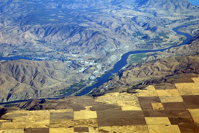
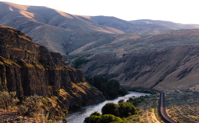
The Yakima River Canyon stretches 27 miles through three major ridges between Yakima and Ellensburg, with summits that rise more than 2,000 feet in places. A railroad and two-lane highway cling to the base beside the river.

In late February, we made our Umtanum ascent, including the bald eagle observation, the first in the valley in 25 years. It was the middle ridge, as I recall, and forms a pivotal chapter in my novel Nearly Canaan.

Thinking of my nature poems … man, the legions of demigods, takes something away, reduces the richness of the land … Nancy Trueblood’s “in the mountains I feel closer to God” … limits the diversity of the species, the expansive quiet, the wonderful circling weaves … in Indiana, my nature poems were often at the edge of the woods — the interface of man, land, and seasons … historical depth where farms sometimes expressed a harmony … a deep cold springhouse, a summer porch … the mountains here, ever green or, like our desert ridge, light brown, are something else … and man adds nothing …

~*~

10 July, Sunday

Drove along Sauk Creek to Stevens Pass … [north of Ellensburg]

Gold-mining remains … introduction to Leavenworth and then the North Cascades …

Leavenworth, with its Swiss Alps festive mood … shame that something similar cannot be created/sustained in “American” or Native authentic theme … maybe something to do with America’s lack of holy rivers and mountains or maybe our flat “Christian” approach to life … (Swiss Calvin not withstanding)

~*~

18 July … apricots gone

~*~

31 July/First-day evening

No entries in a week —

Last Sunday, left early for Seattle (after a midnight Saturday shift) to meet Bill and Mig Dietz and Curtis and Jacquie. The whole port city bit: winos, sailors, loggers, porno shops (me, buying newspapers!), Blacks and students, crowded Sunday parks, jazz. Got to know Curtis better, though their planned North Cascades backpacking got jettisoned by Jacquie’s emergency retinal surgery. His gentleness and humor, plus his Seattle friend Bob Green. Our disappointment with the Seattle art museum, then learning it was cut in half, with anything modern at City Center. The aging freaks and the strangest cats.

Met the Dietzes for dinner at Ivar’s, pier 54. How beautiful these people are. Bill’s ability to melt Kitty’s sharp questioning from Jacquie …

Had salmon, scallops. [Not crab?] The Yakima, a sleek new ferry, in the next pier. Seagulls and seafoam.

Heard of one Friend’s decision to go to Australia, though she didn’t have enough cash to get a visa. Hitched to SF, her first ride was with a trucker who CB’d ahead, starting a chain that got her safely, quickly down the pike — always the next ride waiting. Got to the SF consulate office, sat outside till she got a “hardship” visa. Got her case heard. And went on her way, after staying at Friends House.

The uncommonly filling spirit at our parting. So high, elated from this visit, happy to be together, laughing aloud on our long drive home with a new moon.

~*~

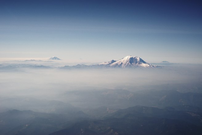
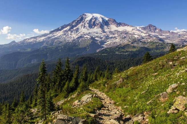
Mount Rainier, photo by William B. Jacobs via Pexels.

Fremont lookout

Rainier National Park

7,200 feet sea level

Kitty joined me in the ascent from Sunrise; thought she’d stop at Frozen Lake but seeing children’s tracks felt shamed into continuing. Amazing Alpine natural gardens …

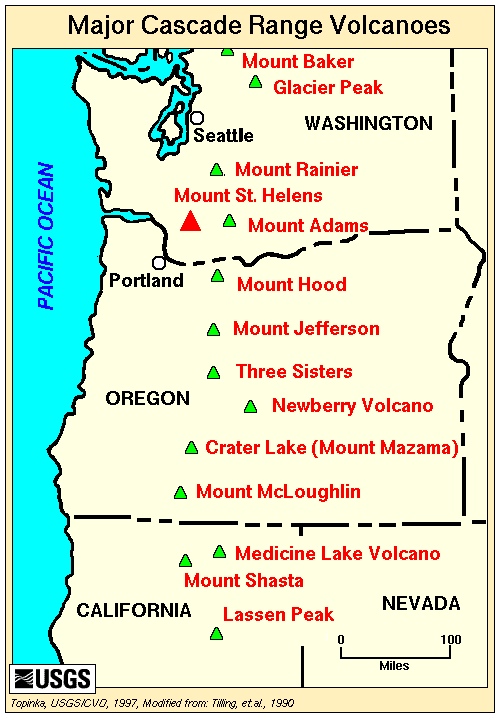
Clearest day one could hope for: Adams, Goat Rocks sharp view from the trailhead, yet a violet haze layer over Puget Sound from Olympia to Mount Vernon.

Next page a sketched panorama map showing Mount Baker, Glacier peak, and the Stuarts … plus notation, “Olympics a blue ragged line riding above the haze.”

Sitting up here’s just like riding a cloud.

And thus we are cloud-riders being ambushed by ’monks,

the fearless chipmunks attempting to ride our lunch …

~*~

From Spiralbound Cascadia with commentary.
 

Not all of my exploration of our new world was on foot or on wheels

My encounters with the unfamiliar terrain of the Western mountains and desert had me reading everything I could find. The public library was a good start.

As I noted:

Rainier, honeycomb mountain, radiating heat under all that ice and snow — so fragile a good explosion could level it all … a new appreciation for “the temple tops” …

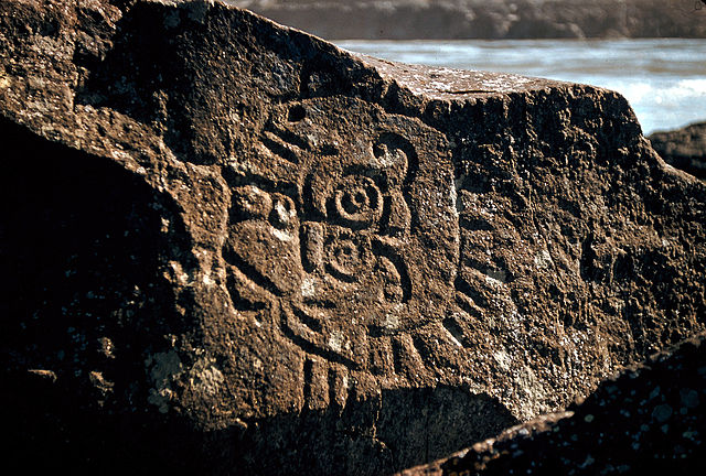
Regarding petroglyphs at the Dalles, to the south of us on the Columbia River:

“It seems impossible to decipher these inscriptions satisfactorily as it is not likely anyone except the makers and those living at the time the work was done could tell what was meant by them” — Newcombe, 1907

Also in Beth and Ray Hill’s Indian Petroglyphs of the Pacific Northwest, 1974, University of Washington Press:

“To make my name good” as a Northwest Native’s goal in life …

~*~

Petroglyph from the Columbia River at Rocky Reach Dam Museum, Chelan County Washington. Rock was rescued from the shores of the Columbia River before the dam flooded it, but many more were not saved. Photo by Thayne Tuason.


Indigenous petroglyphs in Columbia River Gorge near the Dalles Dam by U.S. Army Corps of Engineers, photographer unknown.

~*~

My explorations fill a number of poems and much of my novel Nearly Canaan and of Kokopelli in the Secret Side of Jaya. In fact, I’ve considered the place to be a central character in itself.

~*~

One book I found most useful in understanding the social differences in the Far West was Anti-California. Many of the points its author raised regarding the Golden State fit what I was seeing in the Pacific Northwest. For instance, few children grew up within a day’s drive of their grandparents or aunts and uncles. He saw that as extending into social life in general, which tended to be more polarized, using the Roman Catholic church as an example in having both one of the most conservative cardinals in the world as well as an entire order of nuns that broke away. (I could add that Quakers there came in two opposite camps, liberal “unprogrammed” meetings and pastor-led evangelical churches.) You get the idea. The author had been a correspondent for Newsweek magazine and other respectable periodicals. I didn’t recall the 1971 book’s subtitle, “Report from our first parafascist state,” or know anything about the author, Kenneth Lamott, father of novelist Anne Lamott. As I’m now hearing, he was quite a flamboyant character, to put it mildly. I do wonder how I’d see that book now.

~*~

From Spiralbound Cascadia with commentary.
 

My initial explorations in the Cascades

The primary attraction had been the mountains. We were in the foothills on the eastern flank of the Cascade Range. I was getting out into the wild probably every week from summer to the start of winter. Here are a few excerpts.

Darling Mountain

One of my first exploration, maybe the first, was on a Tuesday I had off work, when I drove up the Middle Fork from Tampico and then logging roads to Darling Mountain crest. Sheep scats and tracks around the snow and awesome meadows. Old site of forest fire lookout, since torn down. Climbed a dead tree to enhance the view. Mount Hood, above clouds. Adams, thrusting into them, closer. Goat Rocks across the way, and St. Helens’ perfect cone beyond. Straight ahead, following the road, Rainier thicker into the clouds somehow superior to the others. Then, a golden eagle sailing straight toward me, turning off perhaps 30 yards away, soaring off, circling briefly, and disappearing. With my guest status, I gave gratitude.

Deep forests were extraordinary.

I had no idea that this was on the second-highest logging road in the state.

Cowlitz Chimneys (center) with the Goat Rocks (background) from Sunrise point on Mount Rainer, photo by Steve Redman at Wikimedia Commons. 

Rainier route

On another trip, on my way to Mount Rainier, saw my first petroglyphs (rock inscriptions) and petrographs (rock paintings) outside of Naches. The paintings looked a little faked — red and white, perhaps with a little blue or red.

They were found near where the Naches and Tieton rivers veered off westward toward the Cascade Range. Photo by William Borg.


Photographs by Robert Niles via Wikimedia Commons.

Our routes to Rainier were progressions through ecosystems that became familiar over repeated exposure as we drove from sagebrush desert into ponderosa pines and reservoirs of future irrigation waters on our way to the high country of the Cascade Crest and the rainforests beyond.

Rainier hikes inspired many poems as well as scenes in my novel Nearly Canaan.

Each day trip was intoxicating.

To the south

John Day Dam in Columbia River: fish ladder and 80-foot drop of locks: air in stomach, at man’s mass of cement: aluminum company by the RR tracks.

Steam locomotive at Maryhill State Park, reflecting Sam Hill’s source of wealth: Maryhill Museum of Fine Arts, his castle above the palisades, green lawn dropping off into clouds. The sculpture studies by Rodin the claim to fame. During the trip, pondering Mount Adams vs Rainier …

Sam Hill Memorial Bridge and Columbia River, seen from Maryhill Museum of Art, Maryhill, Washington. Oregon at top/right. Photo by Joe Mabel at Wikimedia Commons.

~*~

Along the way

Sweet vinegar smell of hay [up to 5 mowings a year in the interior Far West; the hay was grown in the sunny lands east of the Cascades, and much of it was trucked to dairy farms and other livestock operations on the rainy western side of the mountains].

~*~

From Spiralbound Cascadia with commentary.
 

Newfoundland is really out there

It’s a remote land of icebergs, northern lights, puffins, and moose, the easternmost part of Canada. Now, for a few details.

  1. Although the province also includes Labrador, making it larger than California, the usual focus is on the island itself, the world’s 16th largest, ahead of Cuba, Iceland, or Ireland. The island aka “The Rock” sits at the mouth of the St. Lawrence River, creating the world’s largest estuary.
  2. It has the only verified Viking settlement in North America, around the year 1001, possibly with Leif Erikson. The UNESCO World Heritage Site is on the northern tip of the island and includes restored sod buildings; for a sense of the size of the island, it’s an 11-hour, 20-minute drive from St. John’s. Legend has Irish Monk St. Brendan arriving in the 6th century, and Englishman John Cabot may have landed in 1497. Portuguese fishermen were also prominent explorers.
  3. Newfoundland was an independent country before joining the Canadian confederation in 1949. It’s one reason it’s not considered a Maritime Province like Nova Scotia, New Brunswick, and Prince Edward Island.
  4. It has its own time zone, a half-hour ahead of Atlantic, although, strangely, it appears a half-hour later, as in “9 a.m. Atlantic, 9:30 Newfoundland.”
  5. Getting there can be convoluted. Flying from the U.S., for instance, generally takes nine hours; driving, 36. There are two ferry routes from Nova Scotia – the shorter one runs six- to seven-hours; the longer one, 16 hours.
  6. Just 12 miles away, off the southwestern coast of Newfoundland, are the islands of St. Pierre and Miquelon, technically part of France and a vestige of what was once New France.
  7. The Newfoundland dog and Newfoundland pony are symbols of the province.
  8. As for those striking North American puffins, 95 percent of them live in Newfoundland and Labrador, a good reason it’s the official bird of the province.
  9. Between 400 and 800 icebergs a year typically get as far south as St. John’s. Hamlets further north, such as Twilingate, get even more.
  10. It’s pronounced NEW-fundlund. Its people, informally, are Newfies – and Canadians second.

While we’re at it, do note that the Rock has some eye-raising town names. Here’s a sampling, without explanation or commentary:

  1. Dildo.
  2. Goobies.
  3. Tickle Cove.
  4. Blow Me Down.
  5. Come by Chance.
  6. Witless Bay.
  7. Cow Head.
  8. Gander.
  9. Placentia.
  10. Botwood.

St. John’s, the provincial capital and largest city, is not to be confused with St. John, New Brunswick. Both are significant seaports.


How many of the busiest airports have you flown into or from?

They’re not always ones you might expect. On the top ten list you won’t find Boston’s Logan, New York’s Newark, San Francisco’s SFO, or Seattle-Tacoma, for instance. Globally, Paris, Amsterdam, Seoul, and Beijing miss the list.

For this Tendrils, we’ll look closest at the USA. I started out basing the measure by what the industry calls scheduled seats but have switched to passenger volume, not that I know the difference other than it alters the ranking slightly, notably with Chicago dropping from No. 2 to No. 8. Do note these rankings can be confusing, and may shift around a bit if we look closer.

Should you be curious, English is the international language of aviation when it comes to pilots’ and air traffic controllers’ communicating. In contrast, French takes too long to convey essential information.

That says, here goes, however tentatively.

  1. Hartsfield–Jackson Atlanta: ATL is king of the skies, both as the busiest airport in the U.S. — and the world. Its dominance arises in being Delta Air Lines’ largest hub, making it the primary gateway to nearly every U.S. city, but especially Florida and the South. Despite having relatively limited international traffic, its massive domestic network keeps it soaring.
  2. Dallas/Fort Worth: DFW’s sheer size – at 26,8 square miles, larger than Manhattan, and set midway between the two cities – allows its domestic connectivity, a result of being home to American Airlines, to support the cliché claim that everything’s bigger in Texas, boosted in part by the state’s population boom and heavy air freight action. DFW winds up as the eighth busiest airport internationally, too. Measured by aircraft movements, DFW ranks as the third-busiest airport in the world; by passenger traffic, it’s the world’s second-busiest. As I was saying about those definitions?
  3. Denver International: DEN is built on a 53-square-mile campus, giving it more room to grow than any other airport in the U.S. It does have a 16,000-foot runway, the longest public use one in America, is the biggest hub for Frontier and Southwest airlines, and has 27 airlines providing nonstop service to 230 destinations throughout the Americas, Europe, and Asia, making it the sixth busiest internationally. Ride ‘em, cowboy?
  4. Chicago O’Hare: Traditionally the nation’s second-busiest airport, ORD has been eclipsed by Dallas and Denver. Located 17 miles from the Windy City’s downtown, ORD’s strategic location in the Midwest still makes it one of the busiest transit points in North America, driven by United Airlines and American Airlines hubs. Last July 20, it set an all-time record for daily Transportation Security Administration screenings, 115,962 passengers. That was part of the busiest month ever for U.S. air travel, when TSA agents screened 85 million passengers. Globally, ORD ranks eighth
  5. Los Angeles: LAX remains the top West Coast gateway, especially with heavy traffic from Asia. Internationally, it’s 11th. The airport is getting a massive facelift in preparation for the city’s upcoming 2028 Olympics.
  6. John F. Kennedy: With its international long-haul flights, especially across the Atlantic, driving growth, New York’s JFK also ranks 19th The crown jewel of a historic massive redevelopment is a public-private partnership is the new Terminal 6 with JetBlue and Vantage, with the first gates expected this year and full completion in 2028.
  7. Charlotte Douglas: Bet this one flew under your radar, but CLT is a crucial hub for American Airlines. Major expansion includes a $1 billion Fourth Parallel Runway scheduled to open in 2027. Repeated, this North Carolina operation has earned recognition as North America’s most financially efficient airport.
  8. Harry Reid: Las Vegas continues to shine as a leisure travel powerhouse, but there’s more to the metropolis than gambling and conventions. The fact that LAS is a central airline connection to much of the Southwest was the reason I placed Cassia in my novel What’s Left there during her years as a financial field representative. Globally, the airport ranks 24th.
  9. Orlando: Taking over from McCoy Air Force Base after its closure in 1975, MCO does much more than welcoming tourists to Walt Disney World. Its location between sunny coasts has made it a hub for a cluster of flights serving Florida. MCO ranks 25th Welcome to the sunshine, you snowbirds.
  10. Miami-Dade: As the busiest gateway to Central and South America and the Caribbean, MIA conveys major cargo traffic in addition to international travelers. For American Airlines, it’s the third-busiest hub. Globally, MIA comes in 27th.

As for those world rankings, Dubai International comes in third. Not surprising, since the modern city was premised on the international airport’s luxury terminals, duty-free shopping, and emerging strategic global connector. Tokyo Haneda ranks fourth. London’s Heathrow, fifth. Istanbul comes in seventh. Indira Gandhi, ninth. And China’s Shanghai Pudong International Airport, tenth.


Typical comments from our cruise ship visitors

In season, we like interacting with the passengers from visiting cruise ships. Eastport does limit the ships to no more than one a day, and most of the ships come after the summer season and many of our retailers had traditionally closed up. For the restaurants and stores, the ships more than doubled the retail season and often provide the best days of the year. What a relief!

So here’s a sampling.

  1. There are no yachts! This is a real working harbor!
  2. Where can I find a lobster dinner? Or a fresh lobster roll.
  3. It’s so lovely. (Or, quaint. Or, charming.)
  4. Is this typical weather? (Think of June with temps in the lower 50s.)
  5. What are the winters like? Is snow a problem? How much snow do you get?
  6. Your garden looks great.
  7. This is an island?
  8. Do you have schools?
  9. That’s Canada?
  10. It’s not like other ports, we feel welcome.

 Some inquire about lighthouses or the Bay of Fundy.

The crew members, meanwhile, want to know how to get to the IGA and Family Dollar, where they stock up on snacks and junk food. They quickly establish a kind of ant trail moving in both directions.