

You never know what we'll churn up in cleaning a stall
Not everybody shares my delight in pickles, at least the kind you put on sandwiches, but I pile them on, when I can. I’m not much for lettuce there, by the way – I prefer that as a separate salad.
I like the crunch and acidity the pickles add, or even the sweetness, depending on the variety.

My eyes were opened to this reality the year we went largely vegan when we practiced the Eastern Orthodox feasting for Advent. The hardest part for me was finding snack food. (Well, that plus a satisfactory creamer substitute for my coffee and something in place of cheese and … the list goes on.) Fortunately, my wife makes a great humus, and the wraps can be filling, though bland over repetition. And that’s when the pickles took center stage. A row of the green orbs in the torpedo was truly heavenly.
Not that I stop there. When we’re out to eat, the rest of the family puts their kosher pickles on my plate. Not that I’ll argue.
And then there are the summer pickles, meant to be consumed shortly after the cucumbers taken from the garden and put into canning jars. Sometimes it’s a challenge to keep up with the harvest. As if I’m complaining.
Only in the past few years have I begun to appreciate other kinds of pickles – beets, green beans, and eggs, for instance – dishes that used to appear on family dinners at Grandma and Grandpa’s. Especially on big events like Thanksgiving and Easter. Just how far back in our heritage does that go through generations of farmers?
Anybody else love that pickled ginger they serve with sushi?

For someone raised like me far from the ocean, trying to pin down places along the coastline can be confounding.
Eastport, for instance, lies within famed Fundy Bay yet also has Cobscook Bay lapping its west banks and Passamaquoddy Bay on its east.
What gives?
Well, let’s say the bays are like Matreshka Dolls, one fitting inside another one that fits within yet another one and so on.
Cobscook Bay, for instance, includes the smaller East, South, Sipp, Dennys, and Whiting bays.
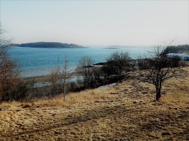
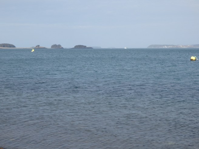
I guess it’s like a New Yorker saying she’s from Flatbush, meaning a part of Brooklyn within New York City, which does – contrary to the knowledge of many Manhattanites – sprawl far beyond their little island.
So Eastport can justly claim to be the City in the Bay. Or several.

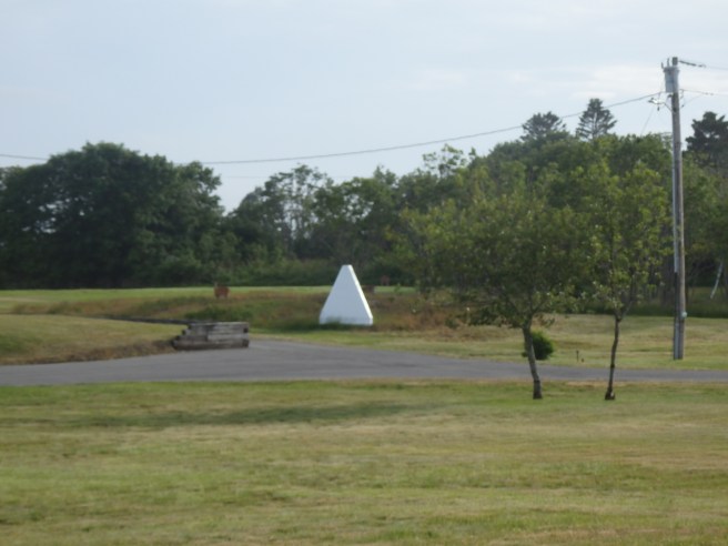
Pyramids like this sit in prominent spots along the shore. They can seem mystifying enough, even before you see a second one nearby.
At last, I learned the two can be lined up to create an imaginary line running out across the water. The border between the United States and Canada falls where the line crosses a similar line running from islands on the other side. That spot can then be connected to others, at least by some kind of maritime surveyors. It’s another example of connect-the-dots.
The four-sided pyramids are called range markers. They’re a special kind of daymark or day beacon, too.
Seeing railroad boxcars away from the tracks around here no longer surprises me. Many of them stand beside farmhouses and sheds or even businesses, where they serve as extra storage space, presumably cheap or for the taking.
But this sight along State Route 191 always grabs me.
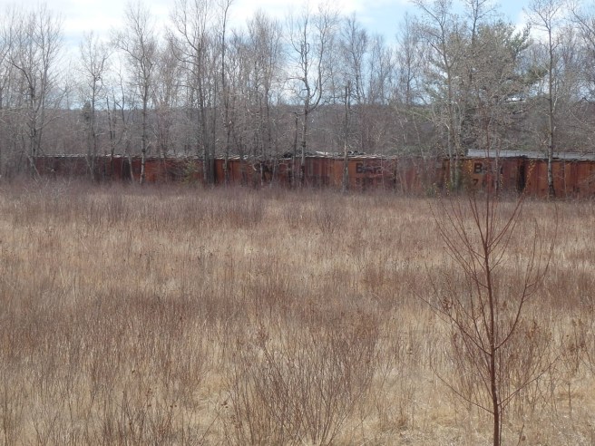
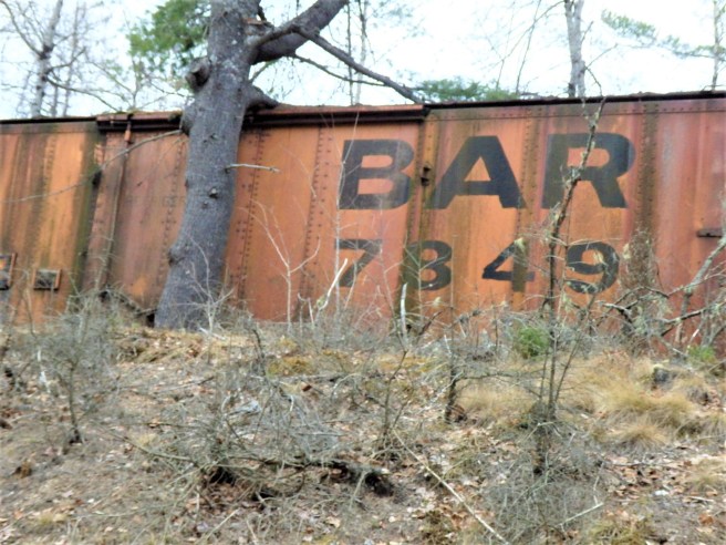
The Bangor and Aroostook Railroad served Washington County as well as the Penobscot Bay region and the spud country up north.
After discussing Maine’s unincorporated townships, I need to add that there are a lot of variants – 17, if I’m counting right. Among them are the BKP, BPP, NBKP, NBPP, and WBKP designations – translated as Bingham’s Kennebec Purchase, Bingham’s Penobscot Purchase, North of Bingham’s Kennebec Purchase, North of Bingham’s Penobscot Purchase, and West of Bingham’s Kennebec Purchase.
So just who was this Bingham guy?
In short, he was William Bingham, already a wealthy Philadelphian when he became filthy rich via privateering during the Revolutionary War. He was also a statesman and U.S. senator who parlayed his riches into vast land purchases, as noted above but also including upstate New York, where Binghamton, where I’ve also lived, was named in his honor.

Quite simply, Bingham owned two million acres in Maine, making him land rich but cash poor.
His agent in Maine, Revolutionary War Gen. David Cobb, was responsible for laying out most of the roads associated with the Airline Highway (now eastern State Route 9). And when Cobb retired in 1820, John Black, agent for Baring Brothers Bank in London, felt that lumber was the wealth that would provide his boss the needed profit. There were further complications as well as marriages, but you get an idea how Baring township in the Moosehorn wildlife preservation got its name.
Cobb did, however, build a great house at Gouldsborough and soon faced some harsh realities that he notated between 1795 and 1800.
First, the land and climate of eastern Maine were not and are not suitable for farming. He noted that “those who come to view the country … have as frequently returned almost blind by the bites of flies and mosquitoes. You have no conception of the hosts of these devils that infest the thick forest at this season.”
More critically, he found “the great body of the people of this country possess no regard to the rights of private property,” calling them ” vicious inhabitants who disfigured its landscape. Every inhabitant here is now a trespasser, a plunderer. They live by it, and therefore they will not cultivate the finest soil in the world. They’re not doing this is the chief cause why the reputation on the country has been damn’d. If the people who live by lumbering are indulged in cutting the forests wherever they please, they will have but little … appreciation of the soil.”
For the record, the soil itself wasn’t nearly that rich.
But continuing, in his estimation, “The greater part … follow lumbering and fishing … and they are very intemperate, very lazy and very poor. It may be said in truth … the majority of the inhabitants are drunkards.”
There are those, of course, who would question whether much has changed since.
Or, as is sometimes said of Eastport, it’s a drinking village with a fishing problem.


