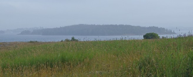
According to the map, it looked like a good road. I had just taken a lovely, very smooth one a few miles to the east, so I expected to enjoy more of the same. But when the pavement abruptly ended, I kept going. After fifteen or twenty miles of encountering no house or other vehicle, I finally came out on the state highway – one of three paved roads running east-west across the county. I did have to back up at one point and try the one intersecting logging road I encountered. Good thing my little Sonic has a compass on the dashboard array. It’s easy to get disoriented in hilly wilds.
Welcome to Washington County, Maine.
The drive had me remembering forays into the logging back country of the Pacific Northwest or even a “shortcut” in the ’50s along Devil’s Ridge in southern Indiana that was pure hillbilly, uh, perfection. I think that route’s long since been covered in asphalt. What a shame – it was timeless.
Long ago, I learned you can’t always trust maps, no matter how much you need them. A tourist site like a commercial cavern might be indicated on the wrong side of the road, or there might be a circle for a village that today is no more than a trio of houses.
Still, they’re pretty essential. As I said, there was one intersection on this trek where my car’s compass had me confounded. Checking the map, I realized I should have turned left and headed south, so I turned about and course-corrected. Good thing, too. According to the map, I would have spent the rest of the day heading into the sunset on a rocky dirt lane.
If I keep this up, I really will need to get a battered pickup or four-wheel-drive SUV.
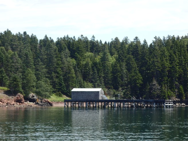
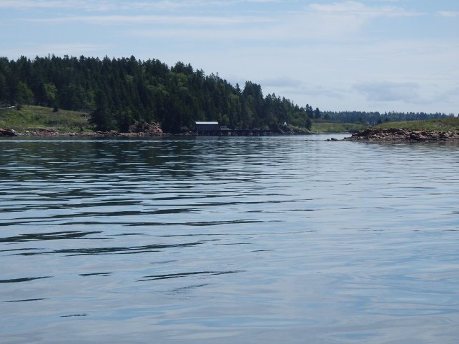
Named for Upham Stowers Treat, the island once housed a fishing hamlet and then a Civil War battery. Today, as one of the Maine Coastal Heritage Trust preserves, it’s open to the public and has a 1.2-mile network of trails offering stunning views of the surrounding bays.
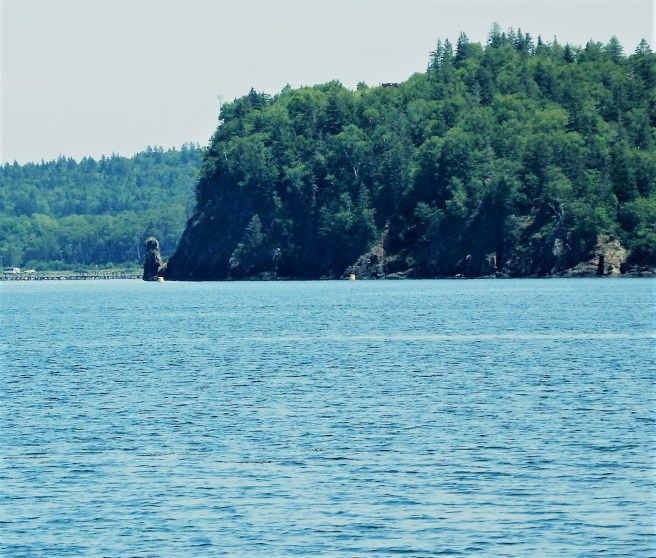
As seen from Eastport’s South Side.
The Army Corps of Engineers operates a marine concrete testing station on three acres on Treat Island’s northwest side.Officially, it’s the largest uninhabited island within the city of Eastport.Dudley Island adjoins Treat.
Kayakers are advised to get a guide who knows the waters’ treacherous currents.
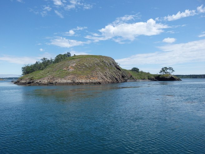
Some early wag exploring the channel that separates Eastport and Campobello Island thought a rock formation visible only at low tide resembled an old monk and dubbed it the Old Friar.
To me, it looks more like an old hound. The poles to the left lead to the Franklin Delano Roosevelt summer cottage.
The headland behind it soon became known as Friar’s Head.
For a little perspective, note how small the Friar looks against the bluff.
As for the channel? It’s Friar’s Roads, curving along the island to its end on the Bay of Fundy.
The Old Friar himself may have lost some features during the Civil War when cannoneers stationed on Treat Island used the monolith for target practice. Canada, apparently, never complained, sparing the U.S. an international incident.
The Passamaquoddy, meanwhile, referred to the pillar as the Stone Maiden. The legend told of a young brave who left on a long journey after instructing his lover to sit and await his return. The distraught young maiden sat on the beach and waited for months. Alas, when he finally returned, he found her turned to stone, forever to wait and watch.
Across the country, pumpkin flavoring seems to infuse about everything on the menu come October, and something similar happens every summer in Maine with blueberries. The tourists and summer people, especially, seem to eat it right up. (Err, couldn’t help myself there.) So it’s not just lobster they come to devour.
Here are some facts about Maine’s in relation to the rest of the nation and world, mostly.
The local brewpub calls its obligatory blueberry ale Skul Clothes. The name puzzled me until I was told that’s how kids traditionally earned the money for their school clothes each year, at least before mechanized machines took over most of the patches. “It’s hard work, down on your hands and knees,” as one recent high school graduate told me. “But the pay’s good.” After that, I could tell the locals who walked in for the first time, looked at the offerings on the chalkboard, and broke out in a grin. They’d all done it.
Ours are lowbush, wild, unlike the highbush varieties cultivated elsewhere. We lead the world in lowbush production, though it’s a drop in the bucket compared to the highbush harvests of British Columbia, Oregon, or Washington state. While Atlantic Canada produces half of the world’s wild blueberry tally, that covers more than a single province – Nova Scotia is the leader there.
Lowbush berries are smaller but more flavorful, in our humble opinion.
They’re also preferred in making blueberry wine.
Blueberries are one of the few commercially-available fruits native to North America. The First Nations, some of whom called them star-berries for their blossoms and the tiny ring at their base, have been eating them for at least 13,000 years
They top the list as an antioxidant and are rich in Vitamin C and even manganese.
Wild blueberry patches are burned every two years.
Wild blueberries freeze in just four minutes.
Some research indicates they counter memory loss in aging. I’ll have to remember that. They’re also good for the heart, cancer-risk reduction, and lowering blood pressure.
I like mine fresh, with yogurt or cream. Pancakes, muffins, jams and jellies come next.
Still, the Old Sow can be seen about a mile away from Eastport if you time it right, about three hours before high tide on the biggest days of the month. The Western Hemisphere’s biggest whirlpool not only swirls but also shoots spouts into the air. As if I could capture that flash with my camera.
The current, though, often runs at seven knots, faster than an Olympic champion swimmer could manage in even a very short burst. It’s also treacherous for Scuba divers, waders, and sailors alike.
It’s by no means the only place to be mesmerized while watching the charge.
Tide pressing from the Atlantic into Dennys and Whiting Bays churns and ripples.
Another impressive sight is the Reversing Falls in Pembroke, though “rapids” would be a more accurate term. The sounds of the waters rushing from one bay to another are as mesmerizing as any waterfall, though.
As the level intensifies, a large whirlpool with a concave depression forms behind the rock ledge, setting off smaller whirlpools around it.The major action is a set of rapids I’d hesitate to call “falls,” though they’re just as noisy. Once the tide comes in, it has to go out, keeping the action going endlessly. As I was shooting this, a pair of seals lolled in the whitewater wings, diving and coming up with fish in their mouths.
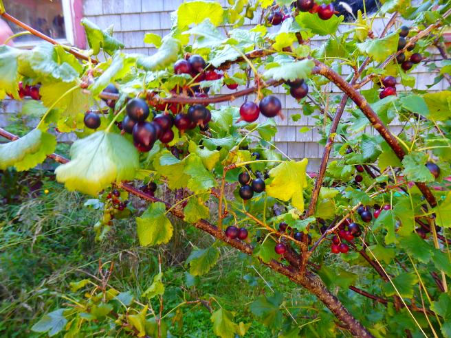
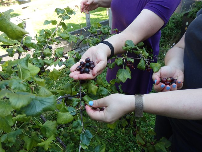
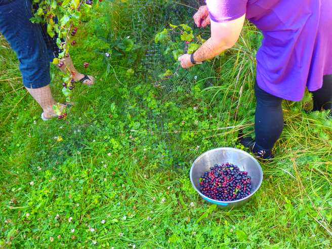
The currants we’re harvesting in Eastport are a different variety than we obtained from the conservation district’s plant sale back in Dover. They’re bigger and juicier, for one thing. And the bushes aren’t as thorny or sprawling, for another.
We got 4½ pounds from a single bush. Most of it will go into jelly.
Funded by a family trust, Cobscook Shores is preserving waterfront lands around Cobscook Bay and its subsidiaries for public use and pleasure. One of its 14 sites is Pike Lands Cove, facing Eastport’s west side across the water from the North Lubec peninsula.
A trail leads out around tidepools I hope to investigate later.
A saltmarsh can be explored up-close.
Here’s where that eagle nearly ran into me. It was being chased by an angry gull. Eastport is across the water.
In writing my history of Dover, I had to face up to the problems of the word “Indian,” which can refer to someone from the Asian subcontinent as much as it does to an Indigenous person of North America. In the end I decided to avoid it altogether unless it was part of a direct quotation or traditional title.
The fact is, the Native tribes themselves can differ widely in their language, customs, and culture, so a generalized label can be downright misleading. And in a particular place, the same people may have been referred to by different labels, depending. You know, the way a Daytonian was also an Ohioan, Midwesterner, or even Buckeye, though not necessarily an Ohio State football fan.
In addition, the tribes themselves may have been much more fluid in their associations than the English and American authorities could comprehend, insisting instead on a more rigid classification.
That was the case with the Passamaquoddy and Penobscots in Maine.
In the Dover history, I ran up against that when some sources called the local Natives Abenaki, while others called them Cochecho or Penacook or something else.
As the Wabanaki Confederacy explains, though, all Abanaki are Wabanaki, but not all Wabanaki are Abanaki.
That said, let’s take a quick look at the Wabanaki.
It’s not a tribe. Rather, the confederacy today is an official alliance of four East Algonquian nations remaining in Maine – Mi’kmaq, Maliseet, Penobscot, and Passamaquoddy.
Historically, it was a looser alliance of tribes stretching from Newfoundland and Prince Edward across Nova Scotia, Cape Breton Island, New Brunswick, and part of Quebec in Canada on to the Western Wabanaki in the Merrimack Valley of New Hampshire and Massachusetts and perhaps beyond into Vermont.
Native names for the affiliation included “convention council” or “orator council,” “be related to one another,” “those united into one,” and “completely united.”
The tribes formed their council after a rise in raids by their ancient enemy the Iroquois League, especially the Mohawks.
In the colonial era, many members aligned with the French, who called the region of Maine the Wabanaki inhabited “Acadia.” Many of the Natives converted to Roman Catholic faith. The defeat of the French in 1763 proved costly for the tribes.
For thousands of years, Mount Desert Island – in today’s Acadia National Park – was a summer gathering place, where they arrived by seaworthy birchbark canoes.
They didn’t live in tepees. They lived in small round bark-covered buildings called wigwams.
Most of them grew squash, beans, and corn, and also harvested berries and other wild fruit.
They didn’t dress like the High Plains Natives out west. They had their own distinctive style.
They loved storytelling and legends. Mount Katahdin, for instance, was inhabited by a half-human, half-bird winged spirit called Pamola who could make the night wind blow or generate snowstorms. And the Maliseet had tales about the little people, who were like brownies or leprechauns.
When I moved to New England more than three decades ago, I tried to take in at least one whale-watch cruise each year, usually out of Newburyport, Massachusetts. But my first time of meeting a live whale came during my first-time ever time in a real sailboat, which was also my first time out on the Atlantic. At first, we saw minkes lolling along at a distance, some of them parallel to our course. And then, just as we were turning into the harbor on the Isles of Shoals, one came up right beside the bow, where I was standing. You can’t say this Ohio boy wasn’t impressed. Minkes may be the smallest of the whales around here, but our 32-foot craft wasn’t much bigger.
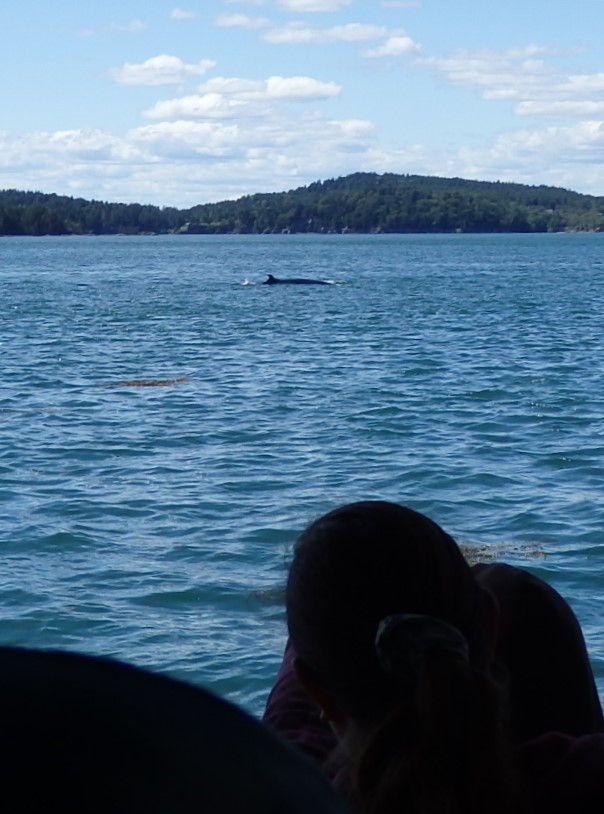
A minke is viewed between Campobello and Deer islands in New Brunswick on a cruise out of Eastport.
Whales migrate up the New England coast each May and linger in its nutrient-rich waters well into October.
One thing I quickly came to appreciate is that there are no guarantees about what you’ll encounter when you go out from shore. What I’ve often called a poor man’s cruise is an experience in itself, especially as you watch land recede and then disappear altogether behind you and there’s nothing save the expanse of sea and sky with occasional birds and boats as punctuation. On one outing, the only whales we found were a minke cow and her calf, which we followed at a leisurely pace. On another outing, so many minkes, humpbacks, and finbacks surrounded us – some close enough to be misted by their stinky blow, others breaching off in the distance – I lost count. Once, we had to be content with a trio of porpoises. You should be grateful for whatever presents itself.
I was trying to get a good shot of the Cherry Island lighthouse but wound up with this moment of a father and daughter from Ohio.
Somehow, though, after I remarried, the annual event faded from the schedule – maybe a handful in 20 years, always with family and sometimes with the kids’ friends. I still have the memories.
Relocating to an old house a block from the ocean has now recharged that. I can walk to the whales. Seriously. In late season, they can even be seen from the shore here.
Here’s a sculpin fish that was in a lobster trap the cruise pulled up as part of its tour of the local waters.
More likely is walking down to Butch and Jana Harris’ Eastport Windjammers and setting forth in one of their refitted lobster boats. The vessels are smaller than the usual whale-watch models but put you much closer to the water. The route, from downtown Eastport out between Campobello and Deer islands in New Brunswick, doesn’t need to go into the open waters of the Bay of Fundy. On at least one of boats, you can even stand beside the captain – usually, but not always, Butch – and, on occasion, each of the kids on board gets to briefly take a turn steering at the wheel.
Don’t scoff when you connect “windjammer” with “lobster boat.” The enterprise comes by its name honestly. Up through 2014, its whale-watch cruises took place aboard Butch’s 118-foot, three-masted schooner, the Ada Lore. But on December 4 that year, a portion of the Breakwater collapsed, wrecking the schooner.
Pursuing whales from a wind-powered deck, I’ve been assured, is the most satisfying way of all to go forth.
I’m ready and willing, should the opportunity present itself.
At times we were joined by what I jokingly call the world’s smallest whale-watch vessel, which sails out of neighboring Lubec. The captains work together by radio to share sightings and other info. Lubec is seen in the background.
What’s been your most memorable experience with the sea? Or some other body of water?