Negative environmental impacts quickly followed

The fur traders’ hot market for beaver pelts in colonial New England soon reduced beaver populations, and fewer beavers meant fewer beaver ponds, an important source of the local Native diet, including roots and waterfowl.

Beavers were only the first of many species afflicted by European settlement in the Piscataqua watershed.

That was followed by the construction of mills, which were powered by water, and that meant dams. Some impounded incoming tides for release a few hours later. These were tricky to operate, though, and changed speeds depending on the strength of the incoming tide or the level of the water during its release.

Dams at the waterfalls became more common.

Either way, dams impeded upstream migrations of fish trying to return from the sea to their spawning grounds. These included salmon, sturgeons, eels, and river herring. Their reduced stocks afflicted both the Natives and the English inland fishing industry.

The mills also produced copious amounts of sawdust that choked river bottoms, reducing and killing off additional species.

The demand for timber itself cleared land all the way back eight to ten miles from the riverbanks, further eliminating wild game. The wood was needed not only for the sawmills but also as fuel for brickmaking, domestic cooking, and warmth through winter. Heating a house commonly required 40 cords of wood a year – no small feat of labor.

And runoff muddied and silted the streams.

Let’s not get too sentimental about the bucolic nature of the era, OK?

~*~

Welcome to Dover’s upcoming 400th anniversary.


A year of puffin-viewing tours to Machias Seal Island sells out in 45 minutes

The narrow, mile-wide island, claimed by both Canada and the U.S., is treasured by many birdwatchers for having the largest colony of nesting puffins along the Maine coast.

Trips to the island are limited, so much so that when online reservations for daily summer visits opened at 8 a.m. on January 10, all the tickets were booked in 45 minutes – at $180 a seat.

Sounds like a real bucket-list item, even if the boat sails from Cutler in my own Sunrise County.

Be warned, too, that the weather can be iffy, meaning that reservation might be cancelled on short notice.

Should I start considering a trip to Newfoundland if I really want to see any of the distinctive birds?

A trail of misunderstanding and betrayal

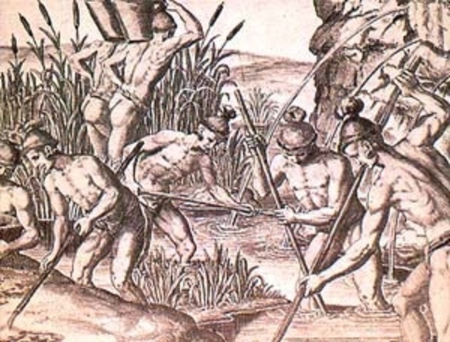
Martin Pring, after becoming the first known European explorer of the Piscataqua River in 1603, then continued south to Cape Cod, where his party engaged in harvesting sassafras tree bark and roots, “a plant of sovereign virtue for the French pox,” as he elaborated in his journal. It was highly lucrative back in Europe and would handsomely repay the Bristol investors backing his journey.

French pox, do note, was what we now call syphilis. If only it worked as a remedy or a cure.

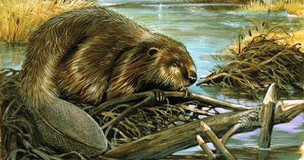
Sassafras was also touted as “good against the plague and many other maladies,” as well, just in case. And you thought it was merely a “tonic” served as tea or the flavoring for root beer?

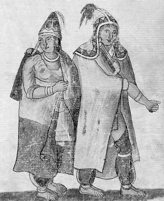
During their six weeks ashore at Truro, Pring’s crew built a barricaded encampment. It was often visited by as many as 60 Wampanoag at a time, sometimes bringing different kinds of food to the party.

In one instance, in response to the playing of a kind of guitar, groups of up to 20 broke into dancing in a ring and singing “lo, la, lo, la, la, lo,” which works when you don’t know the words. For his part, the young musician was rewarded with gifts of tobacco and pipes, fawn skins, and snake skins up to six feet long, “which they used for girdles.”

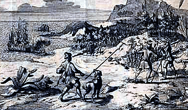
But it was an uneasy relationship. Pring’s two mastiffs in particular terrorized the Natives. Anytime the sailors felt threatened, they’d release the big canines. As Pring recorded, the Wampanoag were more afraid of the two dogs than they were of 20 men.

The tension finally exploded when about 140 “savages armed with their bows and arrows” approached the barricade and a “a piece of great ordinance” was shot off in response as a warning and call to arms.

Recognizing that they’d worn out their welcome, the Englishmen quickly packed up and scooted off behind the protection of the mastiffs and set off for home while the Wampanoag set a mile-width of forest aflame and chased the ship in their canoes.

Of course, we’re never told what so soured the relationship. I doubt that the mariners were very tidy or respectful in their ravaging the forest, and I suspect that may have had something to do with their reaction.

Still, when the Pilgrims arrived in 1620, remains of Pring’s palisades were still visible.

What do you imagine had so enraged the Wampanoags?

Whatever it was, it seemed to set the pattern for much of what followed.

~*~

The episode is rarely told in American history, and, when it is, it’s quickly skimmed over.

Like so much of the New England record that follows, we’re rarely given the Natives’ side of the events.

One thing we can be sure of, though, is that there were huge differences in expectations and values, to say nothing of hygiene or manners.

For instance, as I’ve heard, the Wampanoag word for “treaty” translates as “making relatives,” which is hardly what English settlers had in mind for their part. Far from it. Something similar no doubt happened when the colonists “purchased” land from a sachem.

As the Wampanoag believed, “the land knows you,” more than the other way around.

Quite simply, from their end of these transactions, they were betrayed.

~*~

These days, residing in Downeast Maine – that is, Passamaquoddy country, which stretches over into Canada as well – I’m learning of another series of these one-sided deals.

Joe Clabby’s excellent A History of Eastport, Passamaquoddy Bay, and Vicinity chronicles much of the federal and state maltreatment, misrepresentation, and mismanagement regarding the tribe and its members. One instance, by no means the most outrageous, is this, from 1950: Indian Agent “Hiram Hall allowed the state to charge the Passamaquoddy Fund $8,000 per home for home construction (the homes are worth only $2,500).” This came more than a year after the tribe requested that the state remove him for misappropriation of state aid, favoritism, and disinterest in tribal government.

Driving to and from Eastport, I pass many of these houses, now in serious need of repair. Don’t blame the residents.

As I relate in my new book New England relations with the Natives got off on the wrong foot, starting with the kidnapping of Squanto and four  others. (Virginia hadn’t done any better.)

Shame, shame, shame.

Be among the first to read my new book … for free!

If you’re a reader of ebooks and fascinated by history, I’d love for you to get an advance copy of my new book, Quaking Dover.

In fact, as a follower of this blog, you’re getting a limited-time invitation to pick up a copy of the book for free.

Check it out at Smashwords and its associated digital ebook retailers.

All you have to do is speak up in the comments section of this post, and assuming that your address includes an email (visible only to me) or other contact info, I’ll send you a coupon to download the book in the digital format of your choice within the next 30 days.

It’s one of the advantages of ebook publication at Smashwords.com.

In the world of commercial book publishing, a printed edition typically appears in an Advanced Reading Copy run that allows reviewers, bookstore dealers, and other insiders a chance to hop on before the official publication. In the meantime, the author and editor have time to make fixes and set the stage for an auspicious opening day, one boosted by the buzz of the ARC readers.

So what I’m doing is the equivalent for a digital edition.

The release date on this book isn’t until September 8, but folks who preorder now can get in the front of the line at half-price. That strategy is one step for boosting the book in the crucial first-week sales algorithm.

Today’s offer, however, gives you a chance to own a copy now. In a way, you’ll even be getting involved with the preparations for the tiny city’s upcoming 400th anniversary.

My hope, of course, is that you’ll be excited by my story and happily post a brief review or two in response. If you don’t like it, of course, you can tell me directly and we’ll still have time to rectify that. It won’t even change my perception of you (insert Smiley Face.) From your end, it’s a no-risk proposition.

From my end, I might even gain a fan.

Now, who’s first?

Sawmills, before those for grain

One of the first thing the colonists typically built was a sawmill. From what I’ve seen to date, it always came before a gristmill. I would have thought food would have been the priority, but there are suggestions they imported their flour or even bread instead.

That raises questions of just exactly what their meals were. The Puritans were devoted to their beer and tobacco – and that extended to even their children.

For that matter, how early was Beantown a synonym for Boston?

More than a dozen years after the settling of Hilton Point just across the river, Alexander Shapleigh built the first of two tide mills at his Kittery House estate. Water from the incoming tide was impounded and released later in the day to power the mills. Here’s the site today.
The mill pond remains in today’s Eliot, Maine.

So why sawmills? The early settlers along the Piscataqua apparently erected log cabins, along with fortifications. For that matter, the sole surviving garrison house, preserved at the Woodman Institute, was essentially a log cabin built around 1675.

But flat boards were needed for shipbuilding, wharf planking and bridges, and barrels – for shipping dried fish, especially. Perhaps lumber itself was also an export to Barbados, the Bahamas, and the West Indies.

Let’s remember, too, the construction of dams and mills and their operation required sophisticated skills.

I’m guessing that few of the early English settlers along the Piscataqua were menial day laborers.

~*~

Welcome to Dover’s upcoming 400th anniversary.


Take a sneak peek at my next book’s cover

For several months now, you’ve been getting tastes of my upcoming book, but I have kept much of project under wraps, including the title.

The curtain goes up on that right now.

So roll the drums, please, and take a deep breath of anticipation. Here’s what I’m rolling out:

Do the title and image intrigue you? Pique your curiosity? Hold you for more than a split-second?

As I’ve discussed in previous posts, book covers – and magazines, too – are a specialized design challenge.

The ebook version has to work as a postage stamp, sizewise.

Print editions often get cluttered with pitches of all sorts, just in case one hooks a reader.

An effective title, of course, is a huge consideration, but not the only one.

~*~

Creating a compelling image that matches the content has been especially difficult in this case. The book spans more than 400 years, and I couldn’t find anything that quite reflected the place or its people, now or then, or that extended an appropriate emotional appeal.

A seismograph didn’t do it, though several geometric zig-zag patterns looked cool.

One design that excited me featured a portrait of John Greenleaf Whittier’s mother, but others saw her as forbidding. What I saw calm and collected they viewed as sorrowful and inhibited. Oh, well.

But then, while going through my own photos, I came across a late-autumn photo of the Cochecho River, scene of much of the action. I loved its timeless mystery and beauty and the fact it didn’t look generic to just about anywhere else in the world.

One of my earlier posts pointed out that the cover should promise the reader something rather than mirror the story. It’s a matter of eliciting a gut-level attraction.

Somehow, I hope you feel this cover leads backward into time, with the drama of a storm on the way. Just what is around that bend, anyway?

~*~

Please stay tuned for the release details in the days ahead.

Those who lived here for millennia need to be acknowledged, too

One of the things the Dover 400 project is doing is raising an awareness of the Indigenous peoples who inhabited the region for millennia before European colonists arrived.

The tribes were far more varied than the generic “Indian” label conveys. Sometimes they were in open conflict with each other, and there were many differences in language, culture, and lifestyles. There were also alliances with other tribes, creating subtle but significant relations across the region.

Some lived in permanent villages, often along streams. Others ranged from ancestral site to site through the year in a cycle of fruit, vegetable, and animal fare.

As hunters and fisherfolk who often traveled by water and lived in villages along the shores, many of their names for places are often translated as some variation of “water,” with distinctive nuances that are lost to Western ears but still hint of sharp observation of the character and advantages of each site.

Their name for Hilton Point, for example, is something along of the lines of “place encircled by water,” while Cochecho is more like “foaming falls,” each one, however, unlike other points or coves or waterfalls.

As for our own names applied to these places? I doubt we give them a second thought other than perhaps their spelling.

And, to our loss, we have none of their mythopoetic stories in their original richness – narratives rooted in their unique environment. At least we can begin to listen to those told by surviving tribes in neighboring Maine.

There are good reasons the Abenaki and other New England tribes didn’t dress like the High Plains Natives far to the west.

  ~*~

WHEN THE ENGLISH ARRIVED in New England, most of the tribes had been decimated by pandemics, many of the illnesses resulting from contact with earlier explorers and traders. The sharp loss of population gave the Pilgrims an opening in their settlement at Plymouth.

The first traders brought items the Natives appreciated as useful – metal pots, knives, blankets – that could be obtained in exchange for furs.

As we know, the dynamic changed. We’ve rarely heard the Indigenous voices tell their side of the struggles. The English, French, and Dutch all have barbaric actions to atone for.

The marker at Ambush Rock on Route 101 in Eliot, Maine, for example, makes it sound like the victims were an innocent party on its way home from church one Sunday in 1697. There’s no mention that the prime target, Major Charles Frost, was Richard Waldron’s cohort in the notorious “games” of 1676 that ended up in the arrest of nearly 400 Natives who were then executed or sold into slavery. The Natives waited 21 years for revenge. Frost was the highest-ranking militia officer in Maine.

For me, the missing details change my view of the event entirely. It’s not an isolated instance.

~*~

DOVER WAS IN PENNACOOK COUNTRY, a tribe closely related to the Abenaki – the identities are sometimes merged, suggesting change over time. The Pennacook spanned over much of New Hampshire, neighboring Maine, and parts of Massachusetts. The English jurisdictions didn’t match theirs.

Another consideration is how many of the English settlements occurred at earlier Indigenous villages, as seems to be the case both at the falls in today’s downtown Dover or neighboring Exeter, Newmarket, Durham, Rollinsford, Somersworth, and South Berwick.

A wigwam at the Plimoth Plantation living history museum allows visitors to explore a typical Indigenous winter dwelling. The interior is bigger than you’d expect. (Photo by Swampyank via Wikimedia Commons.)
A Pennacook encampment much like those in the Piscataqua watershed.

~*~

ONE THING THAT WAS OBVIOUS TO ME in a visit to the Plimoth living history museum in Massachusetts was how superior the Wampanoag’s communal wigwams were for living through winter compared to the Pilgrim’s drafty cottages of 1630.

I’m sure the same can be said of the shores of the Piscataqua.

~*~

Welcome to Dover’s upcoming 400th anniversary.

A map is seen much differently from the water

One awareness I’ve gained living in New England is that when you’re out on the water – say in a sailboat, fishing boat, whale watch, or ferry – the geography fits together quite differently than it does on the land.

For example, where I now live in Maine, it’s only four miles or so from our downtown to the one just south of us. That is, if you’re just looking, going by water, or a bird. To drive, though, you have to head north and loop around Cobscook Bay, a distance of 38 miles and about 46 minutes. At least it has no traffic lights.

The water perspective is especially important in understanding the dynamics of early Dover, centered as it was at Hilton Point and Dover Neck between the Piscataqua River and Great Bay. For example, the heart of the town of Kittery was in today’s Eliot, just a mile away by water but 18 miles by land. And today’s Kittery was ten miles downstream or even longer by land.

Hilton Point was just to the left of the “cat” in Piscataqua, while the Shapleigh Kittery House was just to the cat’s right. Getting there by land, though, means going all the way up to the Salmon Falls River. Even finding a map like this of the watershed can be a challenge. Usually, it’s divided by the state line that runs up the river.

Oyster River, or today’s Durham, was only four to eight miles to the west, depending whether you were stopping at wharves along the way or going all the way to the Lamprey River’s falls and the landing.

A trip by boat between Eliot/Kittery and Oyster River/Dover was – and still is – no big deal.

In fact, by water they were closer to Hilton Point than was the village at Cochecho Falls, today’s downtown Dover.

For perspective, I’ve read that a man on the Isles of Shoals thought nothing of rowing ten miles – six of them on the open ocean – for an evening in Portsmouth and then ten miles back in the dark.

In comparison, the relocation of families from Eliot/Kittery to Oyster River becomes much more sensible than a land-based movement would suggest, and much less puzzlingly.

Also, the boundary between New Hampshire and Maine largely dissolves. The watershed becomes the defining perspective.

In terms of understanding history, “Piscataqua” can mean not just the original settlement at Hilton Point but also the expansion across both sides up and down the river. That seems to be the case when Portsmouth, Kittery, and New Castle all claim a 1623 founding.

You might even say it muddies the water.

~*~

Welcome to Dover’s upcoming 400th anniversary.


Selling Natives into slavery was not an isolated instance  

One of the more disquieting things my examination of early Dover and New England stirred up for me is an awareness of a prevalent expression of white supremacy.

It starts out as fear, expressed in the emphasis on fortifications. The Plymouth settlers, for instance, spent much of their first year on building palisades rather than farming, which led to a nearly disastrous shortage of food through the winter. The defenses were apparently intended against Native raiders more than the Spanish, French, Dutch, or pirates.

Later, Puritans required palisades around their houses of worship as well, as happened at Dover’s second meetinghouse, and ordered that all men carry arms, which were lined up against the wall during public assemblies such as religious services.

~*~

THE PREMISE OF WHITE SUPREMACY COMES THROUGH CLEARLY embedded in descriptions of the Indigenous as savages or pagans and is intensified in the resolution of legal conflicts in an unjust system of jurisprudence. Natives always came out on the losing end, with no means of appeal.

Especially telling is the reaction to the killing of John Stone and seven of his crew in 1634 in retaliation for his kidnapping and murder of the Pequot sachem Tatobem. Even though Stone had previously been banned from Boston for drunkenness, adultery, and piracy, and news of his death brought outright joy to some residents in the city, officials demanded the Natives turn over the warriors responsible to face trial. The Pequot, however, refused, even after paying atonement.

Simmering tensions erupted in 1636 after the killing of trader John Oldham and several of his crew on a journey to Block Island, Rhode Island. Even though Oldham was a troublemaker banished from the Plymouth colony, his death caused sermons across Massachusetts and prompted military action that quickly escalated into war.

Telling of the implicit racism is Roger Williams’ line of congratulation to John Winthrop in 1637 for disposing of “another drove of Adam’s degenerate seed.”

Natives being hunted down and captured.

~*~

BY 1638, MOST OF THE PEQUOT had been massacred or sold into slavery in Bermuda or the West Indies. An estimated 1,500 warriors had died in battle or been hunted down. And what followed was a landgrab by the colonists.

Military leader John Underhill, responsible for the massacre of Pequot women and children fleeing their burning village, then came to Dover, where he was briefly governor of the upper province, meaning Dover.

Bluntly? From the colonists’ perspective, a bad white man was worth more than a noble Native.

~*~

SLAVERY WAS PART OF NEW ENGLAND from the beginning.

When David Thomson settled at Pannaway in 1623, he had a Native as a slave, presented to him by an Indian leader. Yes, there was slaveholding among the Indigenous, too.

And whites could be enslaved as well, as was seen in threats to sell Quaker children in the late 1650s.

A key turn in the emergence of Merrymount in 1625 was the sale of some of the project’s indentured English male servants to Virginia and the impending sale of more to the tobacco estates, where death within a year was likely. Thomas Morton used the situation to rally the remainder to resist and stay put, leading to his libertine colony south of today’s Boston.

The origins of African slaves in New England are murky, but Pequots were exported so that they could not escape and return to their families or be freed in retaliatory raids. Instead, they were exchanged for Blacks, who could be held at less risk.

Natives labored in Barbados and the West Indies after being exchanged for Africans as slaves.

In 1637, during the Pequot War, the first American-built slave ship, the Desire, was constructed in Marblehead, Massachusetts, outfitted with leg irons and bars, and armed. She set sail to the British West Indies carrying Boston rum, dried fish, and captive Pequots, and returned seven months later with tobacco, cotton, salt, and enslaved Africans from the Caribbean plantations.

Thomson’s friend Samuel Maverick bought two Blacks as slaves in 1638. Another prominent slaveholder was John Winthrop.

In 1641, the Massachusetts Body of Liberties document included a formal recognition of slaveholding.

~*~

UP TO THE AMERICAN REVOLUTION, despite opposition, some Quakers held slaves, and Dover was not exempt. Up to ten were manumitted, likely with the equivalent of a year’s wages. There’s more on this in my book.

~*~

Welcome to Dover’s upcoming 400th anniversary.