Wet wonder

We haven’t had much rain this year, which makes it all the more amazing when our garden gets some natural relief. This is from one of those rare breaks in our drought.


The asparagus almost looks like a bank of fog.


A broad Brussels sprouts leaf cups clear rainwater.


Prime time for an afternoon along the Atlantic

Fellow blogger Mark Bialczak’s recent posts about his romantic getaway from his home in Upstate New York to the Cape (as we New Englanders refer to Cape Cod) kinda guilted me into giving myself a day off and taking a few hours at a beach a bit over a half-hour’s drive from my little city farm.

Yeah, I know I’m retired (or was, before signing on as a Census enumerator … yesterday was a day off for me). Still, somehow, I get tied down at home. Haven’t swum in the ocean in the past three years, for that matter, not since getting the city pool pass. I always think there’s too much other stuff to tend to.

So yesterday, telling myself the season’s running out, I hopped in the car a tad before noon and simply took off. I thought about heading north to the mountains, but I’d already done a work-related drive in the direction earlier in the day, so I veered east into Maine and settled on Fort Foster, a Kittery town park situated at the mouth of the Piscataqua River.

Regular visitors here at the Red Barn have seen many images from this tranquil alternative to the more popular beaches just up the coast from it. For us, it’s closer than the beaches in New Hampshire, and always less crowded. During the summer, there’s an admission fee, which limits traffic, and for several seasons I opted for a season pass, sometimes spending an afternoon in the water before heading an hour inland for an evening shift in the newsroom. Even so, as I said, for the past several years, I’ve just been more of a homebody, with writing and revising as a top priority.

After Labor Day, the park gate is open only on weekends through September, but it is possible to park outside and walk in, which was the case yesterday. Despite the number of cars lined up along the road, I encountered few people in the park itself, most older couples or individuals walking a dog.

En route, I stopped at the Chauncey Creek Lobster Pier for raw oysters on the half shell, which is always a rare treat for me. It’s a lovely setting, a deck over the water in a narrow tidal passage off Pepperell Cove, and typically crowded. Some diners even arrive by boat. After Labor Day, though, the tourists thin out, making for a perfect time to enjoy our  local attractions. Maybe it has to do with Covid somehow, but the oysters yesterday were smaller than usual, especially for this time of year, when they’ve fattened up for winter. No complaints, though, they were still tasty. If only I could learn to shuck them myself. It’s a skill, one that can lead to emergency-room stitches for an amateur.

‘Nuff background. Here’s a sampling of what I enjoyed a mile or two later.

The road into the park splits, with one branch crossing a marsh filled with cattails. As I walked along it, I was struck by the way Whaleback lighthouse seems to pop from the trees, rather than its usual position surrounded by tides.
For the most part, I had the oceanside trail to myself. Autumn was definitely in the air.
This pebble beach is my usual place to swim. It’s less buggy than the sandy stretches further on, and less crowded than the pocket beaches along the river. My fingers indicated the water was still warm enough for swimming, though I hadn’t brought a swimsuit. September can be some of the best times for swimming, but the cooler air can be a problem. The current also looked a bit rough, not that you see it in this photo.
A wave pours into a tide pool. Had I come prepared, wearing old sneakers and a swimsuit, I would have been in the water, looking under rocks for starfish, urchins, anemone, and other colorful life.


Ten cool facts about glaciers

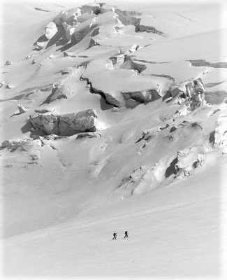
In my novel Nearly Canaan, Joshua and Jaya settle into a place unlike anything they would have imagined. One of its features is the glaciers on Mount Rainier and Mount Adams.

Glaciers are made up of permanent snow cover that’s become compacted into what are sometimes called rivers of ice as they are pushed down a mountainside or valley.

Here are some details.

~*~

  1. About 10 percent of the earth’s surface is covered by glacial ice, but that’s shrinking fast.
  2. Glaciers store about 75 percent of the earth’s fresh water.
  3. If all of the land ice melted, sea levels would rise 230 feet.
  4. During the last ice age, glaciers covered up to a third of the world’s land mass.
  5. Glacier National Park in the Rocky Mountains of Montana has 35 named glaciers. At current global warming rates, none will be left by the year 2030.
  6. Scientists categorize glaciers into eight types, from ice caps and continental ice sheets to hanging glaciers and cirques in depressions on a mountain.
  7. Their surface often appears rough and wrinkled, containing deep cracks or fissures known as cravasses. These can be a deadly hazard for mountain climbers, especially when hidden by fresh snow or a whiteout.
  8. Ice caves melting into a glacier mouth are filled with ethereal blue light during the day.
  9. Antarctic ice shelves calve icebergs that are up to 50 miles long.
  10. To be classified as a glacier, an ice field needs to maintain at least .1 square kilometer of size throughout the year. That’s nearly 25 acres or 19 football fields.

~*~

Have you ever seen one? Up close?

Two climbers pass under a glacier. (Photo by Kurt E. Smith)

More from the Isles of Shoals

White Island, left, and Seavey Island, right. The lighthouse is one of at least four that can be seen from the Isles of Shoals in the daytime. More can be detected at night. Waves crash over the islands in fierce storms.

It’s hard to think that such a small cluster of islands and rock ledges could hold so much attraction, but just look. It’s not just historic Appledore and Star islands that fascinate. Here are some more shots from our day trip.

The entire neighborhood on Smuttynose, the third largest island in the Isles of Shoals. Smuttnose also lends its name to the harbor seals that populate its shores and to a brewery onshore. The Capt. Samuel Haley House, right, is featured on some of the ale labels. The murders of two women in 1873 has inspired poetry, a novel, a movie, and a song. But stories of notorious pirate Blackbeard’s honeymoon there remain unconfirmed.


Lunging Island is privately owned.

Does anyone else envy the summer guests on Star Island?

The historic Oceanic Hotel is now part of a conference center run by a consortium of Unitarian-Univeralists and the United Church of Christ. Its week-long programs are a popular family destination. Cape Ann, Massachusetts, sits on the horizon.

The second largest island in the Isles of Shoals, Star is the only one with commercial boat service to the mainland. The state line between New Hampshire and Maine runs through the small harbor.

Here’s an idea of the hotel’s isolation. You say you want to get away from everything? Apart from your fellow guests, this is just about perfect. But forget about going in winter. That ocean can get wild. 


Closer up. In the 1600 and 1700s, the Isles of Shoals became a major summertime fishing camp, where cod were dried for European markets. They garnered four times the price of Norwegian cod. The chapel remains from that era.

Guests and supplies get to the island on the Thomas Leighton ferry, which plies the waters from Portsmouth, New Hampshire. It can be a jolly experience, if the ocean’s on the calm side.

Regular service. This one’s returning to Portsmouth. Appledore Island rises to the left, while Star Island is just to the left of the ferryboat.


It can be a popular ride. Some people go out as a day trip.

Where the coastline remains an Impressionist impression

Appledore Island scenes like this, off the mainland of Maine and New Hampshire, inspired some of American Impressionist master Childe Hassam’s great paintings.


There was no nude model with her back to us when we visited, unlike at least one of Hassam’s paintings of this geologic rift formation.


One end of rugged Appledore Island is still home to fishermen.


Rockweed on the intertidal zone of a white rock makes a bold image. The standing gulls add their own touch.

How could you not be impressed by Rainier?

I’ve never seen a photograph that captures the breathtaking majesty of Mount Rainier. Even from miles away, it can seem to hover over your head, perhaps even reaching on around for the back of your neck.

Like Joshua and Jaya in my novel Nearly Canaan, I lived in the desert to the east. That meant we usually frequented parts of the national park that the folks from nearby Seattle were least likely to visit.

It’s been 40 years since I was forced to move elsewhere. Here are ten things that still impress me.

~*~

  1. The park: Established March 2, 1899, Rainier is America’s fifth oldest national park. It covers 369 square miles, making it the 21st largest in the continental U.S. and the third largest in Washington state.
  2. The central mountain: Also known as Tahoma, Rainier rises to 14,411 feet above sea level, making it the second tallest peak in the continental U.S. Unlike its rivals, its base is only miles inland from sea level. Measured from base to summit, or by its topographic prominence, that’s 13,210 feet – more than K2 in the Himalayas. It’s the most heavily glaciated mountain in the continental U.S.
  3. It’s a stratovolcano: Rainier is an active volcano, with sulfur-fuming pits in the ice at its summit. Considered one of the most dangerous volcanoes in the world, it leaves about 80,000 people and their homes at risk of an eruption.
  4. Distance from the summit to downtown Seattle: 59 miles, if you’re a crow.
  5. Diversity of ecosystems: About 58 percent of the park is forested, ranging from dense evergreen forest to open ponderosa. The tall Douglas firs and western red cedars are nearly as impressive as the sequoias further to the south. Another 23 percent of the park is subalpine, above the forests but having evergreens at distances. In season, this is wildflower heaven, with orange paintbrushes, lupines, and white-starred avalanche lilies in profusion. Above that, half of the remainder is alpine, having unique vegetation, while the other half is permanent snow and ice.
  6. Year-round ice and snow: Depending on your source, 26 or 27 major glaciers cling to the mountain. They release thunderous booms of breaking ice during the summer. Combined with permanent snow patches, they cover about 35 square miles.
  7. Ice caves: By late summer, the mouths of some of the glaciers melt away to form mystical blue caverns. They’re dangerous to enter but unforgettable if you’ve ever been in one.
  8. Reaching the summit: Climbers are required to register for permits before setting out. They must possess technical skills regarding ice axes, harnesses, and ropes and be in good physical condition. They face a 9,000-foot elevation gain over eight or more rugged miles. And then they repeat it in reverse. For most, it’s a two-day trek. About 10,000 people set out for the summit each year, with half of them succeeding. The mountain claims an average of two lives a year.
  9. Thermal hot springs: Furthest away from Seattle is the Ohanapecosh Hot Springs. Once a resort, it now features trails that are delightful to hike in winter.
  10. Two lodges: Situated at 5,100 feet elevation in the subalpine terrain, Paradise receives an average of 53 feet of snow a year. Sunrise, at 6,400 feet elevation, is the highest point the roads reach. The lodges are often snowed in till the Fourth of July.

~*~

If you’ve ever been there, what would you add?

Mount Rainier from the air. Notice the clouds are below the summit. And much of the white covering is glaciers.